Maps/Trails
Horse Trail Maps
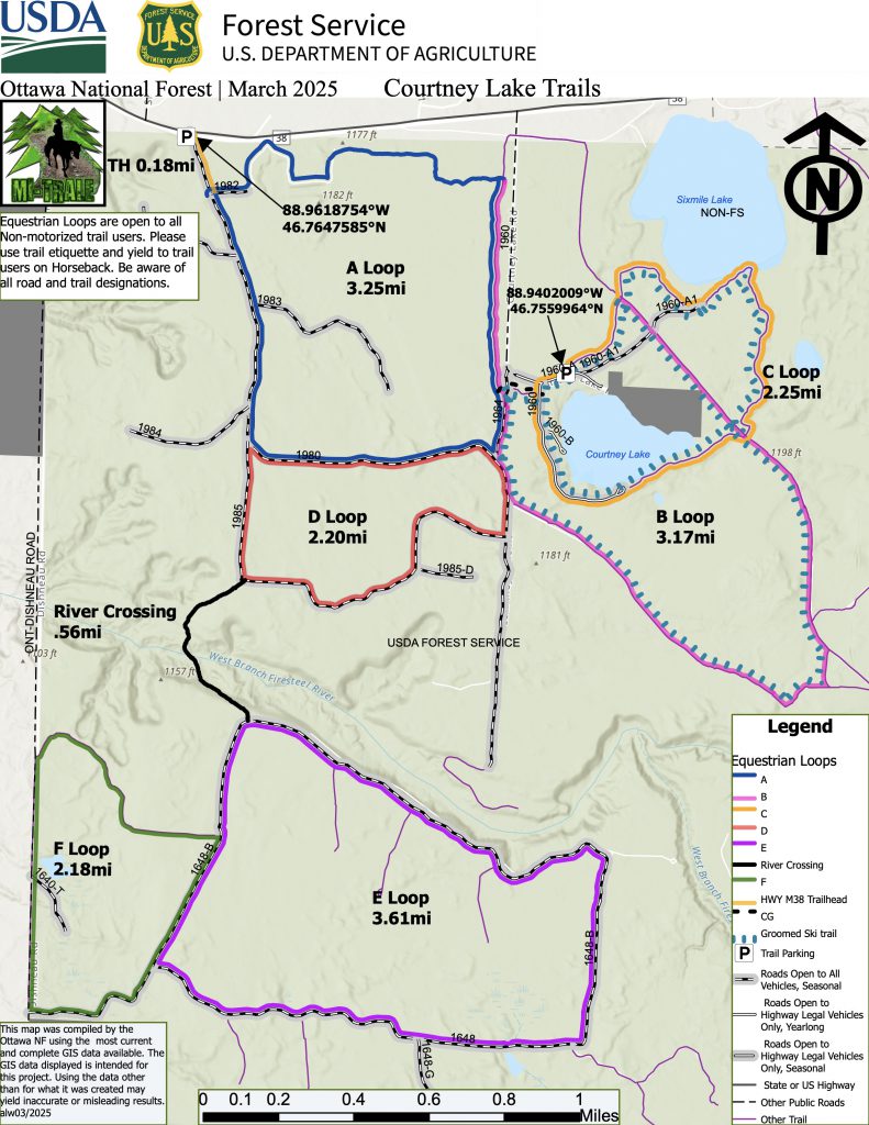
COURTNEY LAKE TRAIL AND CAMPGROUND MAP – UPDATED
The Ottawa National Forest and MI-TRALE have accomplished many improvements to the trails and campground. Click on the link below the map to find the updated map and find new ways to enjoy the trails. “The map will be posted on the trails, trailhead and campground kiosks. You can print the map from the link below or take a picture of it with your cell phone when you arrive at Courtney. Then you can carry it with you when you ride. We look forward to more improvements.”

Courtney Lake Trails are a little known attraction in northeast Ontonagon County on the Ottawa National Forest off M38. These beautiful trails lie on both sides of the West Branch Firesteel River with access points from Courtney Equestrian Trails are a little-known attraction in northeast Ontonagon County on the Ottawa National Forest off M38. These beautiful trails lie on both sides of the West Branch Firesteel River with access points from HWY M-38 and the Dishneau Road. Enjoy the new “Firesteel River Crossing”, which links norther and southern loops. Northeastern loops are enjoyed by cross country skiers, snowshoers and intersect with hiking trails. You will enjoy approximately 18 miles of horse trails on diverse forest landscapes that carry you through areas of hardwood, pine, mixed foliage and forest vegetation. Courtney Lake Campground which is seasonally open has 6 campsites for equestrians with highlines, paddocks and other sites for general public camping. Horsemen can also pack and camp the backwoods at will. This is a peaceful retreat with well-marked trails, cared for by MI-TRALE, local skiers and the Ottawa National Forest. Courtney Lake Trails
MI-TRALE offers a free Map App called “Michigan UP Trails”
The app include HORSE trails along with lodging, food, gas, supplies, services, new trails, points of interests and a trip planner with destination loops and much more. MI-TRALE partnered with the Ottawa National Forest so we added all their trails along with our 520+ miles giving you over 2800 miles of different trails for many different types of users.
Click here for more info on MI-TRALE’s app
MDNR Multi-Use Routes & Horse
Equestrians have use of the multi-use routes maintained by MI-TRALE
Routes are open to other uses including motor vehicles, ATV’s, ORV’s, motorcycles, hikers and mountain bikes so be prepared and stay alert!
Multi-Use Trail Names & Total miles.
Footing Ratings— * “Good “with some Rocks” ** Good. *** Very Good.
* Bill Nicholls Route (BN) 48 mi. -Rail Trail – Trestle Bridges

** Iron River-Marenisco Route (SL) 67 mi. – Rail Trail

*** Land O’Lakes (LL) 26 mi.  – Rail Trail – many Small bridges, beautiful wooded area

* Ottawa East Connector Route (OC) 79 mi. – County Roads, Forest Roads and Forest trails

* Pioneer Trail (P) 23 mi. – Ottawa National Forest

** Sidnaw-Bergland Route (SB) 49 mi. - Rail Trail - Trestle Bridges, Waterfalls, several small tow each offering something unique
SUGGESTED RIDES on MULTI-USE Routes & Trails
RIDE: Bill Nicholls Route (BN) – Map – Rail Trail – There is a public Park N Ride parking area on the corner on M26 & M38 and further north on M26 in Twin Lakes there is parking at the end of the ride if you don’t want to ride back. Once unloaded head a short distance down the side of M38 where you will come to the BN head north/left up the BN trail this will take you over the Bill Nicholls Trestles 100ft above the Firesteel River, you will ride the Copper Country State Forest and end in the town of Twin Lakes.
RIDE: Pioneer Trail (P) 23 miles – Map – Parking in Bergland at the Trail head, also on Norwich Rd and the Greenland Trail Head. Diverse footing, several rocky areas at the north end, it is an amazing trail through the beautiful Ottawa National Forest
RIDE: Land O’Lakes (LL) 14 miles – MAP – On US HWY 45 north of Watersmeet there is the Paulding Pond Camping area on the east side of the road before you get to the town of Paulding there is plenty of parking at the camping sites. Once unloaded head north on the side of US45 to the first road that goes left/west turn and then turn north/right at the T. You are now on the LL Route you will head up the gravel road about a mile where the LL Route signs will turn right through the trees, you will cross back over US45 and follow the signs when you get to a paved road/CW/LL Following the LL to the right 1 mile you then will follow the signs north for another 4 miles of beautiful trails. You will hit another blacktop road where you may continue or choose to turn around and go back to the start.
******SHORELINE RIDE:****** Lake Superior Shore Misery Bay
AGAIN OPEN DUE TO RETURNING SANDS
From the town of Toivola on M-26, turn west onto Misery Bay Road. Continue approximately 7 miles to the DNR boat landing where there is ample parking. Ride your horse on the pedestrian path from the parking lot to the beach. The best riding is to the south (left). To get there, you will have to ride your horse into the lake to reach the southern shoreline. People often use the beach and area immediately next to the parking lot. Please be courteous and please remove manure droppings in that area. There is a latrine, but no potable drinking water. This is a beautiful place for a sunset view!
*********************************************************************************************************
*MI-TRALE MAINTAINS “The Courtney Equestrian Trails” AND OTHER MULTIUSER TRAILS IN THE WESTERN UPPER PENINSULA OF MICHIGAN. HERE ARE A FEW OTHER HORSE TRAILS FOR YOU TO ENJOY!*
MICHIGAN DEPARTMENT OF NATURAL RESOURCES HORSE TRAILS
MDNR DESIGNATED HORSE TRAILS
Upper Peninsula DNR horse trails:
- -Thunder Valey
- -Cedar Run
- -Headquarters Lake EQ Trail
- -Pine Bowl Pathway.
